JERUSALEM AQUEDUCTS, SOLOMON’S POOLS & RELATED SPRINGS
- Ron Traub

- Aug 2, 2020
- 4 min read
Updated: Sep 6, 2020
INTRODUCTION:
The transfer of water without electrification was a major obstacle that had to be overcome by the ancients. As with all villages, towns & cities, both past & present, water was & is an essential ingredient to their survival. Consequently, water sources in the past had to be at a higher altitude than the desired destination point. Topographical obstacles such as valley's & mountain’s between the start & end points had to be overcome. Hence, communities of old had to be knowledgeable in both hydrology - the study of surface water & hydrogeology - the study of groundwater.
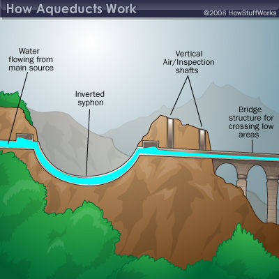
To traverse a valley an aqueduct could be built, alternatively, a technique called "invert siphoning" could be employed. In an inverted siphon the liquid completely fills a sealed pipe which flows under pressure. The laying of the pipes followed the contours of the valley. The dip into the valley caused the water to descend rapidly so that enough momentum was created that enabled the water to travel uphill on the opposing side. Thinking of a roller coaster ride helped me to better understand this principle. (Refer to sketch).
To pass through a hill a qanat was constructed, enabling water to travel from one side of a hill to the other. A qanat is essentially a gently sloping underground water channel for irrigation & drinking purposes, which in addition had vertical air/inspection shafts that descended to the tunnel ceiling. Surface run-off water could be channeled to the air/inspection shaft openings thereby adding to the water volume. (Refer to sketch).
Surface water was conveyed in an open or covered channel.

SOLOMON’S POOL’S: (Refer to map)
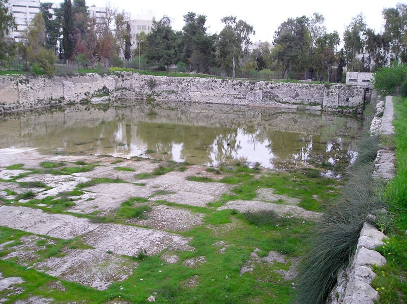
3.5 kilometers south\west of Bethlehem at an altitude of 765 meters above sea level, are 3 large reservoirs, known as Solomon’s pools, which have a total capacity of well over a quarter million cubic meters. Made up of partly hewn bedrock & partly hewn stones, the pools are stepped, with each pool being located about 6 meters below the one above it. The name Solomon’s Pool’s comes from the Book of Ecclesiastes 2:6. “I made myself pools from which to water the forest of growing trees”. The name is however misleading as the reservoirs are not the pools mentioned in Ecclesiastes & hence not built by Solomon.

The first & lowest of the pools was built by the Hasmoneans (167 B.C.E to 63 B.C.E.) & the two upper pools by either the Hasmoneans, Herod (37 B.C.E – 4 B.C.E.) or Pontius Pilate (26 C.E. – 36 C.E.), the Roman prefect of Judea.
Initially the pools were fed by surface run-off water & four nearby springs, namely, the Attan (Eitam) spring, the largest of the four, the Saleh, Burak & Farujeh springs.
FEEDING AQUEDUCTS: (Refer to map)
In addition to surface run-off water & the four residential springs mentioned previously, two post-Hasmonean aqueducts were added. Each aqueduct originated from a different water source resulting in a substantial increase in the water supply to the pools. This done in order to satisfy the needs of the growing Jerusalem population.

THE BIYAR AQUEDUCT was Built by Herod (37 B.C.E. – 4 B.C.E.) & fed by the BIYAR SPRING. It measures 4.7 kilometers in length from the water source to the pools & sloped at a gradient of 1.9%. In other word’s it drops 0.089 meters = 8.9 centimeters = 89 millimeters over a distance of 4.7 kilometers.
THE ARUB AQUEDUCT was built by Pontius Pilate (26 C.E. – 36 C.E.) & fed by the ARUB SPRING. Due to its meandering design, the Arub aqueduct measures 40 kilometers from the water source to the pool’s & sloped at a gradient of 0.09%. In other word’s it drops 0.036 meters = 3.6 centimeters = 36 millimeters over a distance of 40 kilometers.
DISTRIBUTION AQUEDUCTS: (Refer to map)
THE LOWER AQUEDUCT was built by the Hasmoneans (167 B.C.E. – 63 B.C.E.) & traverses a distance of 21.5 km from Solomon’s Pools (765 meters above sea level) to the Temple Mount in Jerusalem (740 meters above sea level) giving it a 1.16% slope. In other word’s it drops 25 meters over a distance of 21.5 kilometers. On its journey it goes through Bethlehem, skirts kibbutz Ramat Rachel, tunnels through a mountain in Talpiot, continues to the Hinnom valley, skirts Mishkenot Sha’ananim, continues to Wilsons Arch & arrives at the Temple Mount.
Remnants of this aqueduct can be seen at Armon ha Natziv in Talpiot, & Mishkenot Sha’ananim. At Armon ha Natziv one is able to walk through an underground water tunnel that is 400 meters in length. The tunnel is punctuated with overhead air/inspection openings, extends from one side of the hill to the other & is 15 meters deep in places.
THE UPPER AQUEDUCT was built by Herod (37 B.C.E. – 4 B.C.E.) & traverses a distance of 14 kilometers from Solomon’s Pools (765 meters above sea level), to the Temple Mount. (740 meters above sea level), giving it a 1.78% slope. In other word’s it drops 25 meters over a distance of 14 kilometers. The aqueduct skirts the west side of Bethlehem, arrives at Herod’s palace which was located within the Old City close to Jaffa Gate, continued to Hezekiah’s pool located in the Christian quarter of the Old City & made its way to the Temple Mount. Initially it was thought to have supplied the Mamilla pool which is located outside Jerusalem’s Old City walls, 650 meters north/west of Jaffa Gate. Excavations undertaken in 2010 revealed that the final segment of the aqueduct was at a much lower elevation than the Mamilla pool & could therefore not have functioned as a feeding source.
Recently an underground connection from the Mamilla pool to Hezekiah’s pool has been unearthed.
The HERODIAN AQUEDUCT built by its namesake, began at Solomon’s Pool’s & descended eastwards through the Artas Valley to the Herodian, a palace/fortress in the Judean desert constructed by Herod. (I have written an article on the Herodian, which can be viewed on my Website blog).
This water system was maintained throughout the Roman, Byzantine, Arab, Crusader, Mamluk, Ottoman & British occupations. It functioned for 2000 years until 1934 when the British began pumping water from Afek (Antipatris) which is located near the modern day town of Rosh HaAyin. The British did however refurbish the Biyar aqueduct along with Solomon’s pools in 1924 providing water for Jerusalem’s Old City up until 1967.
Ron Traub (Tour Guide & Architect). Website : rontraub-tours.com Photo’s & Maps : The internet.


Comments